
New version of Globema’s GeoMarketing application is now enhanced with new functionalities. Spatial analysis tool now incorporates product and service availability zones based on Google algorithms.
The main function of GeoMarketing is to create spatial business analyses supporting decision process in sales, marketing and customer service in retail, real estate, finance or insurance business. The creation of elaborate market scenarios is possible through the combination of company internal information and sociodemographic data with advanced analytical functionality. One of new features is determining catchment areas for cars, public transportation and on foot. Application enables defining catchments for one or multiple points on the map.
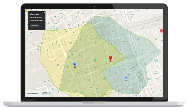
Img. 1 Retail network catchment visualization and their antagonizing zone on one of the settlements.
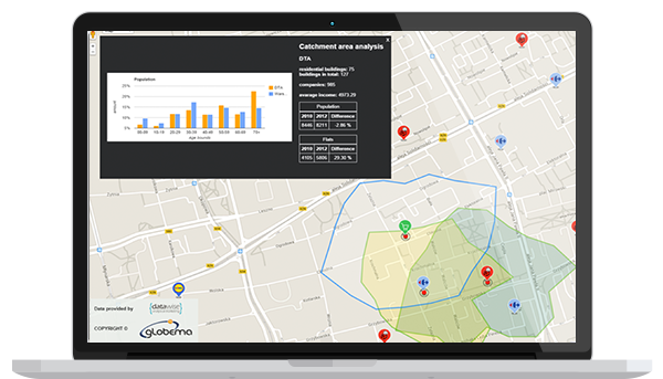
As a result of recent changes the application can download statistic data for predefined areas. The area can be marked out manually by creating polygon or by downloading a catchment. Statistical data such as number of address points, number of businesses or average income can be generated for any given area.
Img.2 Data on population and average income for a catchment area of a new shop competing with two other shops already existing on the same settlement.
In addition to described features new application has preset styles that allow to personalize map elements like: roads, railroads and aeronautical infrastructure, POI etiquettes, public utilities, natural environment (water bodies, forests, parks etc.). Through this most important elements of surrounding infrastructure can be highlighted in reports and final analyses.
Google GEO products offered by Globema