Nowadays, monitoring and managing location data no longer require GIS specialists and complicated desktop systems. Access to geospatial data is now essential to many departments across companies. Such data need to be easily accessible and intuitive for every employee. Statistics show that 80% of organizations collect and store geospatial-context data. Therefore, it’s worth it to take full advantage of their possibilities. But how can you do that? Let’s see!
What are the consequences of ineffective data usage?
When lacking data insights, businesses cannot carry out their operations and processes in an optimal, informed way. This causes business processes to be ineffective, considerably delayed, and over-engaging to employees. All this results in higher costs due to unutilized company resources and information as well as uninformed business decisions.
GeoGrid – a solution for managing data using interactive maps
During our cooperation with utility companies, public administration, and businesses such as real estate or e-commerce, we observed increasing needs related to location intelligence. It’s a process of using geospatial data for solving business problems. To help companies develop their expertise in this area, we created GeoGrid, a system that combines features of a “lightweight” GIS (Geographic Information System) with LI. This allows GeoGrid to combine spatial and business data for analytic purposes – finding patterns and a deeper understanding of researched problems. As a lightweight GIS, GeoGrid has basic features and doesn’t overload the user’s system.
What are GeoGrid’s features?
- The system is offered as a cloud service so it’s ready for immediate use
- It’s easy to use as a web and mobile app
- GeoGrid features a configurable data model that can combine data from different sources
- Geospatial data can be easily used by everyone in your organization regardless of their GIS knowledge
- The system and its users are supported in the collection, transformation, and integration of over 450 data formats and sources thanks to FME, a data integration platform

What are GeoGrid’s possibilities?

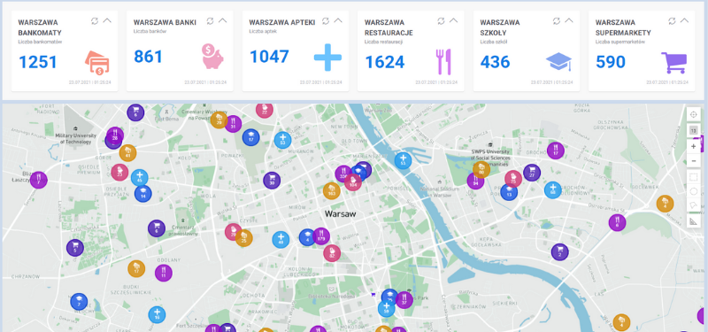
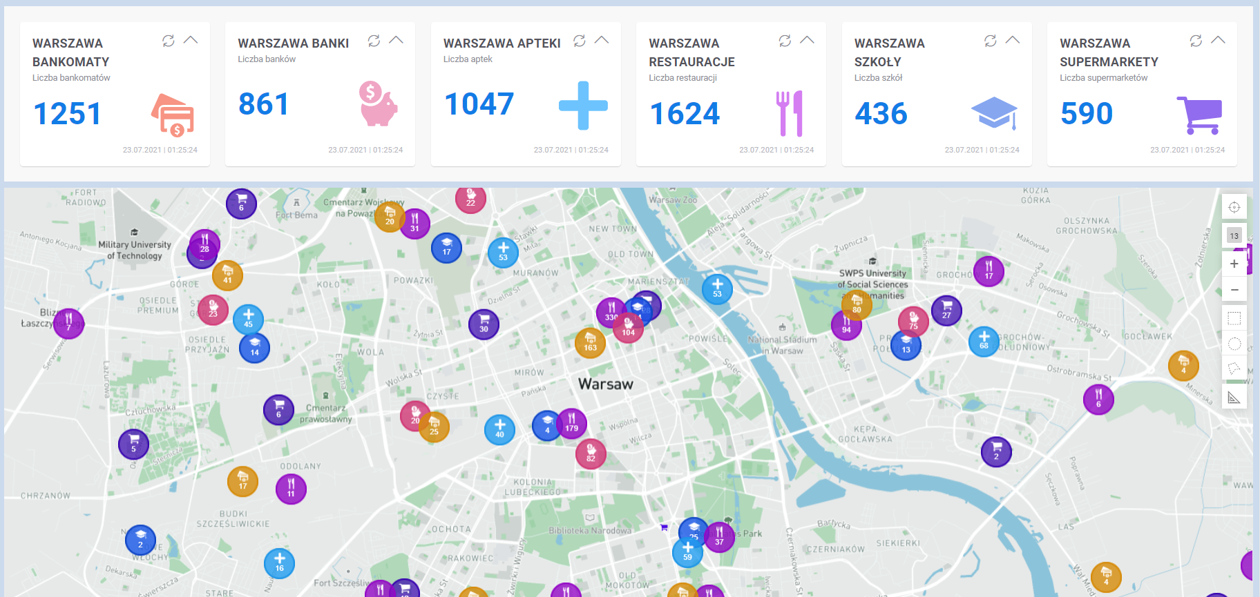
Creating eye-catching, interactive maps
Gain new perspectives from your data and easily find and demonstrate crucial information and dependencies with spectacular maps. Gain enhanced details as you interact with data, zoom in, or search on the map: object attributes, notes, documents, and linked objects. Click on the map to discover location-specific data displayed in object properties, tables, or charts. Map analysis provides you with valuable insights to help you develop your business.

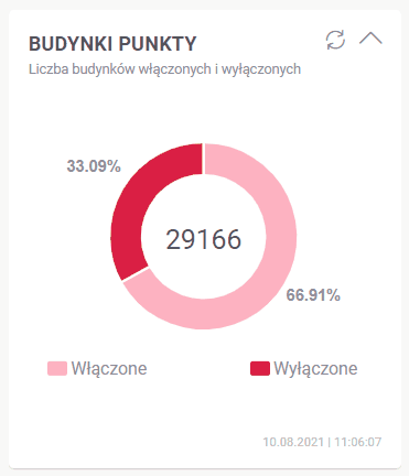
Monitor and manage your assets
Track the status of your assets and the performance in real time to reduce costs and increase efficiency. GeoGrid can be used as a stand-alone solution based on internal and external data sources, displayed as raster and vector layers. It can be also integrated with other systems at your company, including GIS software.

Edit objects and cooperate with other users
The system features object editing tools – you can edit, add, and delete objects to make sure all information is kept up-to-date. GeoGrid allows a group of users to work on the same projects in real time.

Analyze data and browse dashboards
GeoGrid helps to make informed, beneficial business decisions through advanced data-filtering options (SQL query generator), dynamic graphs, and ways to analyze data in a geospatial context.

What are the benefits of using a GIS?
Reduced costs and increased productivity
resulting from wide access to geospatial data and improved process effectiveness
More effective support for fieldwork
through convenient access to data in a mobile or web app. Data can be modified by mobile workers directly in the field
Increased employee effectiveness
thanks to easy access to map data taking into account a role (e.g. a regular user, administrator, designer, editor) and permissions (e.g. editorial, analytical, access to all data or only particular information)
Low implementation cost
as a result of the SaaS model that eliminates the need for system maintenance and updates
Do you need a specialized application tailored to your industry requirements?
Based on GeoGrid components, we develop personalized applications tailored to the unique requirements of our customers’ industries. See some of our solutions:
- GeoGrid DH – a full heating network model with hydraulic calculations
- GeoPerformance for Heating Industry – integrating data from different sources and visualizing them on intuitive dashboards and maps
- LocDoc – automated categorization of scanned documents
- ElGrid – a system supporting the development and optimization of energy network operations
- 4RES – forecasting RES energy production based on professional weather predictions
- PrognOZEr – an up-to-date RES energy production forecast in Poland
- Soral – monitoring the technical condition and failure risk assessment of cable lines