

Learn how FME Platform helped Visimind in the process of collecting and processing large amounts of network data and, based on this data, create high-quality products for Polish Power Grids.
About the project
The technical infrastructure of Polish Power Grids (Polskie Sieci Elektroenergetyczne – PSE) consists of thousands of elements and extends over hundreds of kilometers. Visimind had to provide high quality data about the PSE network and on this basis create a number of top-quality products – including a geospatial database. To meet the objectives of the project, Visimind took advantage of the support of Globema and FME, one of the most popular platforms for geospatial data acquisition and processing.
Table of contents:
Headquartered in Stockholm, Sweden Visimind was founded in 1997 as a continuation of research conducted at the Royal University of Technology in Stockholm. The scientific work focused on MMT (Mobile Mapping Technology), automated measurement methods, and an infrastructure inventory system based on GIS and numerical analysis of digital images. The group provides services and solutions related to photogrammetry, remote sensing and GIS, applicable in such industries and areas as: power and gas, roads and railways, environmental sciences, urban areas. Operating from offices in Sweden, Poland and Italy it cooperates with companies and organisations across Europe.
Challenge
The PSE Project
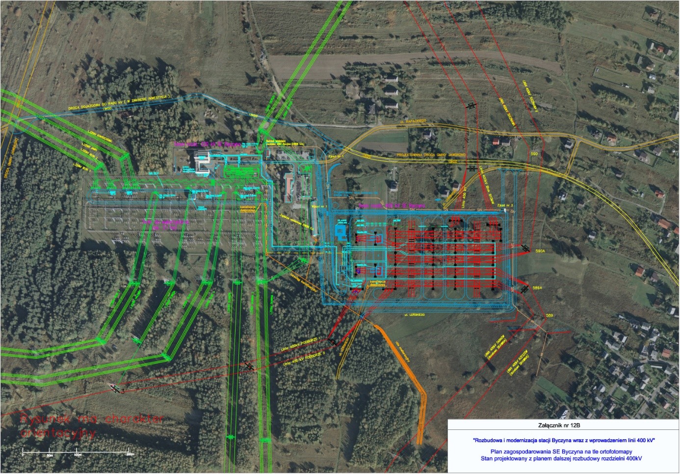
In 2020 Visimind carried out a project for PSE – Polish Power Grids (Polskie Sieci Elektroenergetyczne) – a strategic State Treasury company and Transmission System Operator in Poland. PSE ordered a very detailed inventory of objects in the corridor of their power lines and power stations with precise mapping of the layout of elements of their transmission network, in particular: cables, supporting structures, current paths, cutting areas, and elements related to stations.
Visimind was elaborating data for thousands of kilometersof PSE powerlines and more than a hundred power stations. PSE commissioned photogrammetry flights over their powerlines and power stations with the elaboration of six basic aerial products:
- Point cloud with more than 30 classes
- High-resolution Digital Terrain Model (DTM)
- High-resolution Digital Surface Model (DSM)
- RGB and CIR Orthophotomap (CIR – Colored Infra-Red, created with the use of an NIR – Near Infrared camera, which can be used for a more detailed analysis of vegetation)
- Aerial Pictures of supporting structures
- Geodatabase – one of the most interesting and difficult products to create – a geodatabase including an inventory of all digitized objects visible on the orthophotomap – roads, buildings, powerlines, electric equipment, etc.
In such a big project, covering vast areas of land, Visimind had to face several challenges:
big amount of data that had to be delivered – more than 10TB
80000
pole images
2300
orthophotomap, DTM, DSM
16 000 000
objects in the Geodatabase
unique data delivery structure
range and high quality of the spatial products to be delivered
correctness of the geodatabase structure and objects, their: geometry, topology, attributes (also the compliance of names and SKMS codes – PSE’s internal unique objects ID)
Solution
Why FME?
Given the size and significance of the project carried out for PSE and in order to ensure high quality, completeness of the data provided and to be able to verify and evaluate it via an external tool, an efficient solution was needed. One that could also be used in the future for the implementation and validation of other ongoing projects.
Visimind was looking into different external software that could accomplish the above goals, but FME was the only one that met the multitude of requirements, i.a.:
- multi-data format compatibility,
- spatial and non-spatial data processing,
- raster, vector and table data validation
- output of reports in different formats
- scalability and automation
- processing data in batch mode
- easy to use by persons without a programming background
- ongoing updates and improvements to meet the customers’ changing needs
Visimind executives have been interested in FME software for a long time and have heard a lot of positive feedback about the platform. The final initiator of the implementation of this program was a PSE customer who used FME scripts to validate the received data.

Why Globema?
Visimind decided to contact the only official distributor of the FME Platform in Poland – Globema. The cooperation was very smooth and professional. Globema’s specialists helped to choose the version of the software that would best suit Visimind’s current needs. FME Desktop ESRI Edition was selected.
What’s more, Visimind decided to take advantage of FME trainings and additional technical consultations with an FME specialist from Globema. The training allowed for quick implementation and preparation of Visimind employees for work using FME. It was also a very good basis for further learning about the FME program in everyday practice and for building scripts for subsequent tasks and projects.
Additional technical consultations with an FME specialist from Globema helped to understand the scripts used beforehand by Visimind’s client – PSE. The way they were implemented and can be adapted to the work structure used by Visimind.
Benefits
In the project carried out for PSE, Visimind used the FME software mainly to validate and control the provided data. With the use of FME scripts the following elements were verified:
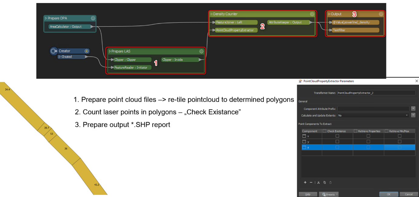
- Point cloud density in defined areas,
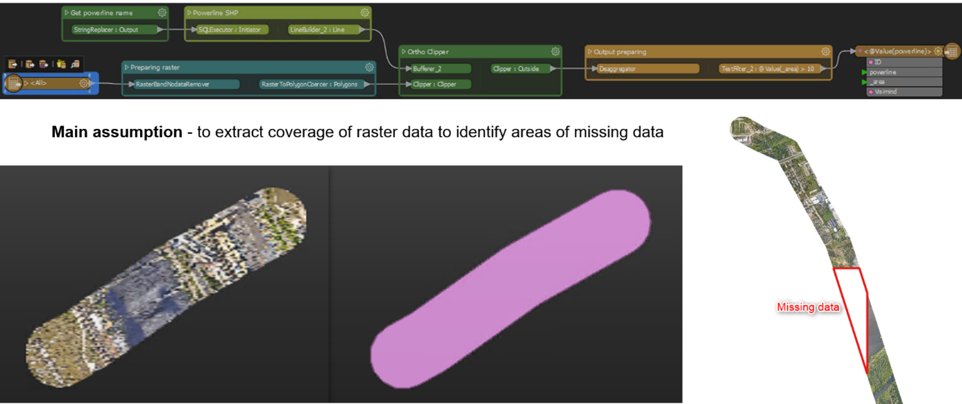
- RGB / CIR orthophotomap, Digital Terrain Model, Digital Surface Model completeness
- Pole photos completeness, quality, and naming
- Geodatabase contents: object attribute compatibility in the Service Knowledge Management System (SKMS) – based on customer documentation, object topology compatibility, object segmentation compatibility,
- Quantity of the data provided.
Raster Coverage Validation Script (source: Visimind Ltd Sp. z o.o.)
Point Cloud density validation script (source: Visimind Ltd Sp. z o.o.)
Faster processes
To provide the data delivery structure agreed upon between Visimind and their client, all scripts were prepared to run in batch and parallel mode. Additionally, a connection to the internal Visimind database in PostgreSQL was used.
All the above aspects allowed for full automation and reduction of the working time of processes previously carried out manually or semi-automatically.
Now, thanks to the use of FME scripts, the processes are carried out much faster:
25
hours
Carrying out the orthophotomap/DTM/DSM completeness control now takes 25 hours instead of 800
5
hours
Checking the completeness of the photos of the poles now takes 5 hours (previously 150 h)
15
minutes
The quantitative data checks take 15 minutes (instead of 15 h)
Another huge advantage of FME was the high accuracy of scripts – impossible to achieve with data control carried out manually or semi-automatically.
Moreover, FME software was used in the PSE project to process and prepare spatial data products. Visimind used FME e.g. for:
- converting final data
- harmonizing client data
- extracting classes from the point cloud
- extracting data from the PostgreSQL database
- preparing shapefiles
- importing data to the Geodatabase
Plans for the future
Visimind has been using, FME Desktop to automate the processing of spatial data and controlling the quality and completeness of the provide products for two years now.
Being aware of the enormous potential of use and savings resulting from the implementation of the FME software, Visimind decided to use FME Desktop more widely in the implementation of internal processes of spatial data processing and validation. It has been decided to purchase the next FME Desktop license to use the software on a larger number of ongoing projects.
Additionally, thanks to generally available webinars and after consultations with Globema, Visimind decided to purchase and launch FME Server.
Visimind is now after a training course from Globema on the use of FME Server and is in the process of creating and implementing a number of automated services, scripts, and processes that aim to optimize and save even more working time.
Thanks to technological development, especially in fields such as geodesy, Global Navigation Satellite Systems (GNSS), broadly understood electronics, and unmanned aerial vehicles, obtaining spatial data has become easier and more common. The real art is no longer the acquisition of data, but its proper preparation, filtering, and efficient processing into products and services that correspond with the current needs of the changing market.
Due to its flexibility, ease of configuration, constant updating, and development, FME is an ideal tool supporting and accelerating everyday work in the processing and validation of spatial and non-spatial data.
Marek Szczepkowski, Project Manager
Visimind
Discover more case studies
Grupa MTP
Saving time and reducing expenses by integrating systems and data sources
Learn how Grupa MTP achieved efficient information flow between different departments and the customers using a data information platform.
FME | Data Integration | Event Planning
Visoro Group
How do you automate manual tasks and upload data with just one script?
Learn how Visoro Group used the FME Platform to automate and speed up data processing and integration by 750 times.
FME | Data Integration | AEC


