
Logistics departments of various companies, big wholesalers, warehouses, distribution networks and other organizations employing drivers and field workers face a number of challenges arising from the specific characteristics of their business. One of the most complex and demanding challenges they have is transport scheduling and route optimization. The task is so complicated that mathematical models were created to describe it. The well-known form of the issue is the “traveling salesman problem”: simple to describe and giving very hard time to everyone trying to find the best solution.
You may ask: how is it possible for business owners to meet the challenge so complicated that it gives talented math minds sleepless nights? Depending on the size of the company, they have to struggle with transport planning (delivery or collection of goods) for dozens or hundreds of recipients, which requires loading numbers of vehicles. Following the combinatorics principles and considering the number of customers, we will see that there are more ways of determining delivery routes than the possibilities of the lottery results. Therefore, selection of the optimal routes (accommodating road conditions, access constraints, load building rules, vehicle capacity, availability of docks, etc.) becomes even more complicated than the mentioned “traveling salesman problem”.
Without dedicated tools, route optimization and transport scheduling are time consuming and expensive. Usually, a team of specialists spends several hours per day to create such a plan and still the result is rather far from the ideal. To answer these challenges, we’ve developed GeoTraxx application, built on top of Google Maps.

Do we really need IT tools to optimize delivery routes?
We already know that designating an optimal route manually is time-consuming and complicated. What about IT tools? Do they solve the problem? Let’s take a closer look at the case of one of the largest logistic centers operating in Poland.
Every day the center delivers goods to about 300 – 400 stores. The number of recipients depends on the supply needs, season and day of the week. Important facts to notice: people responsible for scheduling must designate routes and goods to specific vehicles and start the picking process as soon as possible, so that trucks could leave the center next morning. To optimize both, loading and deliveries, the vehicles are loaded in accordance to the LIFO principle – last loaded goods are first to take at deliveries.
In order to estimate if and how GeoTraxx could support such processes, we’ve taken data from the following five days and prepared transport schedule in accordance to customer’s requirements. The chart below shows how the total number of kilometers decreased after using Globema solution based on Google Maps.
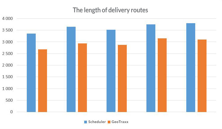
As we can see GeoTraxx has shortened the route by an average of 19%.

The application plans delivery routes in a way so that you can use your cargo space to the maximum and get additional benefits through optimal loading. In this case, automatic optimization tool allows us to use 1-2 vehicles less a day.